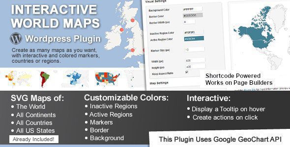
Interactive World Maps 2.5


Discover the Power of Interactive World Maps 2.5: Your Ultimate Mapping Plugin
In today’s digital age, visual storytelling and geographic representation have become essential tools for businesses, educators, travelers, and organizations alike. The Interactive World Maps 2.5 plugin offers an innovative solution to create stunning, interactive maps tailored to your specific needs. Whether you’re showcasing global travel routes, highlighting regional data, or presenting company locations, this plugin empowers you to craft visually appealing and highly functional maps with ease.
Key Features and Capabilities of Interactive World Maps 2.5
The plugin is packed with features that make map creation intuitive, customizable, and dynamic. Here’s a comprehensive overview of its core capabilities:
| Feature | Description |
|---|---|
| Global and Regional Maps | Create maps of the entire world, individual continents, countries, or specific regions. Perfect for detailed geographic visualizations. |
| Divided Countries & States | Display countries divided into regions or states, such as U.S. states or European subdivisions, for more granular insights. |
| Customizable Colors & Markers | Assign individual colors to regions, use colored markers of varying sizes, and customize background and border colors to match your branding. |
| Interactive Features | Hover, click, and zoom functionalities enhance user engagement, making maps more informative and user-friendly. |
| Multiple Map Types | Display maps of the United States divided by metropolitan areas, or regions within countries, providing detailed geographic breakdowns. |
| Background & Border Customization | Adjust background colors, border widths, and border colors to create visually appealing maps aligned with your site design. |
| Responsive Design | Ensures maps look great on all devices, from desktops to smartphones, maintaining interactivity and clarity. |
Ideal Use Cases for Interactive World Maps 2.5
This versatile plugin is suitable for a wide range of applications, catering to various industries and purposes. Here are some of the most common use cases:
Travel Websites & Tourist Agencies
- Showcase Destinations: Highlight popular tourist spots, travel routes, and service areas.
- Interactive Itineraries: Allow users to click on regions to view detailed travel information.
- Travel Planning: Enable visitors to visualize their journey across multiple countries or continents.
Multinational Corporations & Small Businesses
- Location Mapping: Display office locations, warehouses, or service centers worldwide.
- Market Analysis: Visualize regional sales, customer distribution, or expansion plans.
- Brand Presence: Show the geographical reach of your brand or products.
Non-Governmental Organizations & NGOs
- Project Areas: Map regions where projects are active or ongoing.
- Resource Allocation: Showcase distribution of aid, volunteers, or resources across different regions.
- Impact Visualization: Present data on program success or community development metrics.
Educational & Infographic Content
- Geography Education: Create interactive lessons on world geography, regions, and countries.
- Data Visualization: Present statistical data in an engaging manner, such as population density or climate zones.
- Infographics: Develop visually appealing infographics for reports and presentations.
How to Download and Use the Interactive World Maps Plugin
Getting started with the plugin is straightforward. Follow these simple steps:
- Download the Plugin: Visit the official website or marketplace where the plugin is hosted and download the latest version of Interactive World Maps 2.5.
- Installation: Upload the plugin files to your content management system (CMS) or website platform, following the provided instructions.
- Configuration: Access the plugin settings to customize your maps—select regions, choose colors, markers, and interactivity options.
- Embedding Maps: Use shortcodes or embed code provided by the plugin to insert maps into your pages or posts.
- Optimization & Testing: Ensure maps are responsive and functioning correctly across devices. Disable AdBlock if necessary for proper display.
Note: If you encounter issues with the free version, consider disabling AdBlock or trying another web browser. Always scan your files for viruses or malware before installation.
Customizing Your Interactive Maps for Maximum Impact
Personalization is key to making your maps truly stand out. Here are some tips:
- Use Distinct Colors: Assign different colors to regions based on data categories or status, such as sales regions, climate zones, or project areas.
- Adjust Marker Sizes: Vary marker sizes to represent data magnitude, such as population size or revenue.
- Set Background Colors & Borders: Match your website’s color scheme for a cohesive look. Use border widths to emphasize boundaries.
- Interactive Labels & Tooltips: Add informative labels that appear on hover or click to provide additional context.
- Include Legends & Tables: Incorporate legends to clarify color codes and data representations, enhancing usability.
Frequently Asked Questions (FAQ)
Q: Is the Interactive World Maps 2.5 plugin compatible with all websites?
A: The plugin is designed to be compatible with most popular CMS platforms and websites. However, always verify compatibility with your specific setup and ensure your platform supports the required features.
Q: Can I customize the appearance of the maps?
A: Absolutely! The plugin allows extensive customization, including colors, markers, borders, background, and interactivity settings, to match your branding and design preferences.
Q: Are there limitations on the number of maps I can create?
A: No, you can create as many maps as needed. The plugin supports multiple maps, each customizable independently.
Q: How do I ensure my maps are mobile-friendly?
A: The plugin is built with responsive design principles, ensuring maps adapt seamlessly to different screen sizes. Test your maps on various devices to confirm optimal display and functionality.
Q: What should I do if I encounter issues or bugs?
A: First, try disabling AdBlock and switching browsers. If problems persist, contact the plugin support team or consult the documentation. Always keep the plugin updated to the latest version for optimal performance.
Conclusion: Elevate Your Content with Interactive World Maps 2.5
The Interactive World Maps 2.5 plugin is a powerful tool that transforms static geographic data into engaging, interactive experiences. Its extensive customization options, ease of integration, and versatile applications make it an indispensable resource for website owners, educators, marketers, and organizations seeking to visualize data compellingly.
Whether you’re showcasing global travel routes, mapping out business locations, or creating educational content, this plugin provides the flexibility and features necessary to produce professional-quality maps that captivate your audience. Remember to tailor your maps with colors, markers, and interactivity to ensure they align with your goals and branding.
Start exploring the endless possibilities today by downloading the Interactive World Maps 2.5 plugin and take your geographic visualizations to the next level!